I mentioned to my friend Ann Marie the other day that I’d paddled to Mark Island.
“What’s that rock?” she asked me.
I asked her which rock, but I sort of knew. I had stopped to photograph the rock. It’s so obvious because it’s stark white against a bunch of darker rock around it. Seems out of place, and it is, sorta.
Here’s a picture.
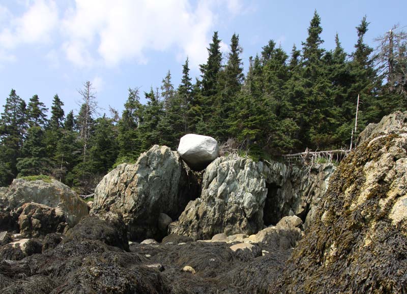
That’s a “glacial erratic” and we see them all the time in Maine. Not all of them are so obvious.
It’s a kind of rock that is not indigenous, not part of the local bedrock, “from away” as we say in Maine.
Thousands of years ago, it was broken off some mountain to the north by a glacier. It tumbled around under the glacier for a while, being smoothed and ground down. Then the glacier melted and this was left where it lay, on top of a hump that, eventually, became Mark Island in the middle of Penobscot Bay.
Maine’s geology constantly fascinates me and I told Ann Marie about it. It can be roughly summarized by three processes, each taking considerable lengths of time:
- 400 million years ago (or thereabouts) silt and diatoms settled out of an ocean onto the ocean floor, creating mud. This happened for a long time and made a really thick bunch of mud and sand that eventually compressed into rock. This “sedimentary” rock was then slid westward until it bumped into what would become North America. Under pressure and heat, it buckled and smushed, all the while keeping its layers mostly intact. This is our “sedimentary metamorphic” rock. It started its life as sediment and has layers to prove it, but the layers go in all different directions, are curved and mashed, with intrusions of quartz (where things got really hot). This is pretty typical in places like Casco Bay and Muscongus Bay. But the sedimentary rock also explains the limestone around Rockland and Rockport (both named for the “limerock” found there).
- Then much later, some earthly indigestion got going. Great gobs of molten magma bubbled up from within the earth in huge domes called “plutons.” The plutons pushed the other rock out of the way in some places and hardened into what are now mountains and islands, mostly granite with, here and there, a bit of basalt. Monhegan is mostly basalt, as is Mark Island and some of the islands of western Penobscot Bay. The Camden Hills and Acadia are various granites.
- Then even later, it got cold. Snow fell and fell and fell, until Maine was covered with a layer of ice a mile thick. And the ice was moving, crushing everything under it and pushing great piles of rock. All that stuff acted like sandpaper, smoothing the bedrock below and scraping away millions of tons of rock. When the glaciers finally melted, they left behind fairly smooth mountains and islands and loads of stuff that had been dragged many miles from where it started.
That’s the ten-cent, seat-of-the-pants, amateur summary of Maine geology but it explains the vast majority of what you see here. Knowing the above, you can usually decode what kind of rock you are walking on. And you’ll start to see things differently. Hiking up Cadillac a few weeks ago, I could clearly see the scratches of rocks being dragged over the mountain by glaciers.